Looking for the macroinvertebrate photo gallery?
Schuylkill Project Overview
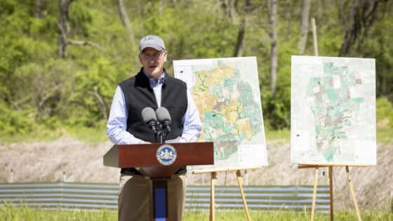
 Download the Schuylkill River Project report summary
- Download the Schuylkill River Project report appendices
Our Schuylkill River project is an effort to describe stream water quality throughout the 1,900-square mile Schuylkill River basin in southeastern Pennsylvania. We assess stream condition by sampling the macroinvertebrates (mostly insects, crustaceans, mollusks and worms) that live on the stream bottom.
The presence of particular types as well as their relative abundances are combined with knowledge of the ability of the various types to withstand pollution to come up with a water quality “score” for each site. Water quality scores identify poor quality streams in need of mitigation, high quality streams worthy of special protection, and fair quality streams that may deserve intervention to prevent them from becoming poor quality streams.
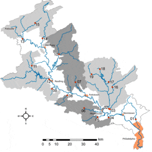
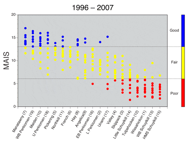
This study ran for 12 years, from 1996 to 2007. Included are data from 19 long-term study sites on major tributaries that are sampled each year. These sites provide a current and long-term assessment of watershed health throughout the basin. An additional 120 sites, located upstream from the original 19 sites and sampled in one year only, provide a more complete picture of conditions within the major tributaries within the Schuylkill basin. Throughout this website, sampling sites are color coded to indicate water quality conditions, with blue signifying “good,” yellow “fair,” and red “poor.”
History of the Schuykill River Basin
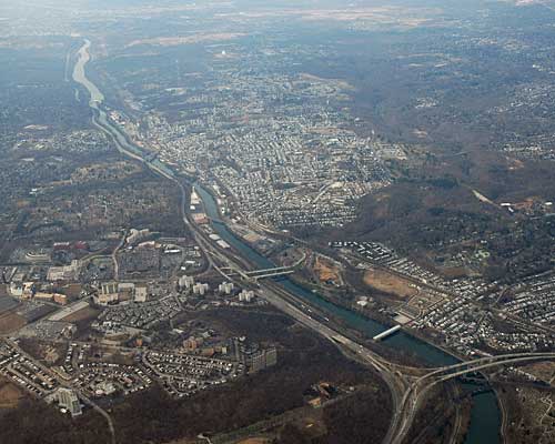
Few river basins have had a longer or stronger connection to socioeconomic, cultural, and industrial development in the United States than the Schuylkill River Basin. This is because the land and water of the Schuylkill Basin have provided many of the resources needed over the last 350 years by colonial, industrial, and even modern Philadelphia, which lies at the downstream end of the basin.
When Europeans colonized the Basin in the 1600’s, it represented vast forests for lumber, rich soils for farming, miles of streams and rivers for fishing, drinking, transportation and power, and deep beds of anthracite coal as a major energy source. Over time, the forests were completely harvested, thousands of acres were farmed, many tons of coal were mined, and most of the streams were dammed, diverted, pumped, and/or polluted. Concurrent with these activities was the conversion of forest and farmlands to urban and suburban developments.
The basin today bears little resemblance to the pristine woods found by the first Europeans. However, it is still an invaluable natural resource for the 3 million people that live in the watershed as well as the additional 3 million people from neighboring watersheds that together represent the Philadelphia metropolitan area. For example, forests have regrown to cover about 41% of the basin, and now represent important areas for recreation, wildlife, and potentially silviculture. Agriculture still occupies 40% of the acreage while developed lands represent about 13%. Finally, surface- and groundwater resources in the Basin continues to provide drinking water for more than 3 million people.
Macroinvertebrates as Indicators of Water Quality
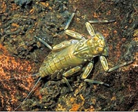
This study uses benthic (i.e., bottom-dwelling) macroinvertebrates such as insects, worms, and crayfish that live in the River and its tributaries to assess current water and habitat quality. Benthic macroinvertebrates were chosen as the focus of this monitoring program because they are the most common group of aquatic organisms in water quality assessment programs (Hellawell 1986), they have provided water quality assessment programs with valuable insight for more than 100 years (Cairns and Pratt 1993), and they are now integral in watershed education and outreach programs.
Aquatic insects are commonly included in biological monitoring programs that assess water quality in streams and rivers for a number of reasons (Weber 1973, Hawkes 1979, Hellawell 1986):
- Most reaches of a given stream or river ecosystem support relatively diverse (100-200 species) aquatic insect assemblages that include species from several different groups of insects [e.g., Ephemeroptera (mayflies), Trichoptera (caddisflies), Coleoptera (beetles), Diptera (true flies)]. Because each species potentially has different tolerances of environmental change and stress, this diversity can result in hundreds of independent environmental measures that, taken together, provide a relatively sensitive measure of environmental change and stress.
- Their limited mobility and relatively long life spans (a few months to at least a year) make the presence or conspicuous absence of an aquatic insect species at a site a meaningful record of environmental quality during the recent past, including the occurrence of short-term and/or infrequent events that might be missed by assessment programs that rely on periodic water chemistry samples (Weber 1973).
- Aquatic insects form a critical link in the food web, functioning as primary consumers (herbivores and detritivores) of plant and microbial matter and serving as the primary food resource for secondary consumers, especially fish (Weber 1973, Hawkes 1979, Hellawell 1986).
- Their abundance (number of individuals/m2) lends itself to statistical analysis, which can play an integral role in modern water quality monitoring programs.
As of 2001, macroinvertebrate monitoring protocols had been developed in every state but Hawaii (USEPA 2002). Unfortunately, this has yet to contribute significantly to citizen-based stewardship and advocacy because most streams are rarely sampled, and current data and classifications are often regulatory in nature and therefore not released or are technically complex. Our Schuylkill River project provides the information and tools needed to encourage citizens (children, adolescents, and adults) to interface with local organizations and governments, and with state and federal agencies.
Project Goals
This study has three long-term scientific and education goals:
- To establish baseline data that can be used to describe and evaluate water and habitat quality (current and long-term) in the Schuylkill River basin based on aquatic macroinvertebrates collected from numerous locations distributed throughout the basin,
- To make this assessment available to local education outreach and community groups in order to encourage efforts to assess, improve, and/or protect water quality in these streams and rivers, and
- To provide local college students experience in a long-term scientific study, collecting and processing scientific data that will be compared to past data and used in future studies.
It is important to keep in mind that an assessment of current water and habitat quality in the Schuylkill River and its tributaries reflects both past and recent anthropogenic activities. Some scars from past anthropogenic activities are no longer evident while others remain, although time or mitigation may have concealed them or lessened their impact. As a result, caution should be applied in the interpretation of monitoring data when only observations of recent anthropogenic activities are available.
Sampling Methods
Study Area and Sites

The Schuylkill River, which drains ~4950 km2in southeastern Pennsylvania, flows for 211 km through several population centers (e.g., Pottsville, Reading, Pottstown, Phoenixville, Norristown) before its confluence with the Delaware River at Philadelphia. The Schuylkill basin is composed primarily of forest and agricultural land (~85% combined), with most remaining land classified as urban. The watershed has a complex topography and geology as it flows through three physiographic regions (i.e., the Ridge and Valley Province, New England Province (Reading Prong), and Piedmont Province).
In 1996, we identified 19 study sites that were located on most of the major Schuylkill River tributaries and included streams of varying sizes, physiographies, and land uses. Together, watersheds upstream of these sites represent 57% of total basin area. Watershed land use varied among sites: agricultural land ranged from 5% (Headwaters Mainstem Schuylkill) to 66% (Tulpehocken Creek); forested land ranged from 21% (Skippack Creek) to 75-77% (Angelica Creek, Headwaters Mainstem Schuylkill, West Branch Schuylkill); urban land cover was high for Wissahickon Creek (49%), Valley Creek (42%), Skippack Creek (24%), and East Branch Perkiomen (12%), but only 0.6-7% for most other sites; and mining operations were 7-9% of land cover for the West Branch Schuylkill and Headwaters Mainstem Schuylkill, 1.5-2.5% for Little Schuylkill and Valley Creek, and rare or absent for all other basins.
There are over 250 dams distributed throughout the Schuylkill River basin, including in our study streams (Poten 1996). These are generally low head dams that create relatively small impoundments, but there are three large reservoirs in the basin: Green Lane Reservoir on Lower Perkiomen Creek, Blue Marsh Reservoir on Tulpehocken Creek, Lake Ontelaunee on Maiden Creek. Most dams on the study streams were located either on upstream tributaries or >10 km from the actual study reach. The Site 12 was 150 m downstream from a low-head impoundment and several km downstream of Blue Marsh Reservoir while Site 17 was downstream of several small impoundments.
Each of these 19 sites integrates the upstream activities within each watershed, and represents water quality in the tributaries just before they enter the mainstem Schuylkill River. This assessment provides an overall evaluation of efforts to protect, mitigate, and restore these tributaries and watersheds. It also provides important perspective when examining new sites. These sites were sampled annually to provide a measure of annual variation in the stream communities and its impact on stream assessments, to generate the data needed to assess long-term changes in stream conditions, and provide simultaneous data to provide perspective when evaluating data from other sites. Beginning in 2001, we worked with local watershed associations and other interested parties to identify additional sites (12-31 per year, 127 total) to provide spatially detailed information in specific watersheds in the southwest (2001 and 2006), upper (2002), northeast (2003 and 2006), northwest (2004), Perkiomen (2005 and 2006), and northwest, southwest and northeast (2007) tributaries.
Sample Collection and Processing

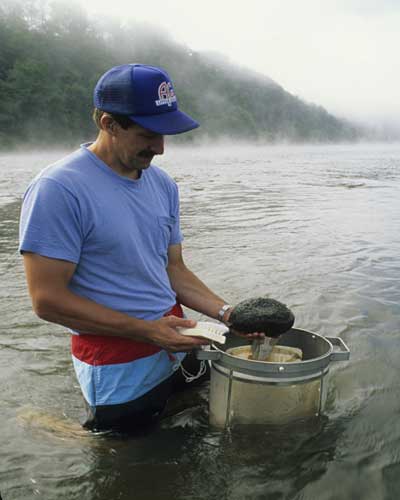
Macroinvertebrate samples were collected annually (between late March and late April) for 12 years (1996-2007) at the 19 Long-Term study sites. The other 127 sites were sampled only once, between late March and late April from 2001 to 2007. Five quantitative samples were collected randomly from a single riffle at each site using a modified Hess sampler (0.088 m2 sample area; 500 µm mesh net). During sample collection, the substrate was disturbed and dislodged macroinvertebrates were collected in the sampler’s net. Each stone (large gravel to cobble) in the sampling area was scrubbed with a brush and then inspected for any remaining attached macroinvertebrates, which were then removed by hand. Although substrates were generally similar across all samples (mostly small to large cobble), the quantity of leaves, woody debris, and sand/silt associated with the cobbles varied among sites and years.
After collection, macroinvertebrate samples were preserved in 95% Ethanol, transported to the laboratory, and split into four or more equal subsamples. Subsampling reduced the number of individuals examined from each sample towards our target of 200 individuals per subsample. Because macroinvertebrate densities varied greatly across sites and years, the subsample size processed varied from whole samples to 1/16 of a sample. Macroinvertebrates were removed from subsamples under magnification and identified to family (most insects) or order/class (most non-insects) using keys in Peckarsky et al. (1990) and Merritt and Cummins (1996). The samples were processed in the laboratory by 88 college students (5-14 summer interns per year) recruited from 43 colleges or universities. The students were provided initial training in macroinvertebrate identification techniques, and they quickly acquired the skills needed to collect data with taxonomic content similar to family-level data commonly collected by state and federal agencies. All identifications and counts in every sample were rechecked after initial processing.
Water samples were collected at each of the study sites (one sample per site) during baseflow. Nitrate (NO3), total dissolved phosphorus (TDP), pH, conductivity, and alkalinity were measured for each sample.
Data Interpretation
No single descriptor of aquatic macroinvertebrate assemblages is generally accepted as better than all others (i.e., most accurate and sensitive) (Resh and Jackson 1993, Barbour et al. 1999). Thus, the macroinvertebrate data were summarized as estimates of density for individual taxa or groups of taxa, and with community structure metrics that are commonly used in water quality monitoring programs. Each of the variables described below is calculated with information from the same data set, which results in a certain degree of redundancy among the descriptors. Thus, when meaningful changes in aquatic macroinvertebrate assemblages occur, we would expect that those changes would be apparent in changes for more than one descriptor. Not all macroinvertebrates were identified to the family level because of specimen size, damage, or taxonomic limitations. Thus, our estimates of richness may slightly underestimate actual richness.
Density
The macroinvertebrate samples are quantitative because the animals are collected from a known area of stream bottom enclosed by the modified Hess sampler. This allows the macroinvertebrate counts to be expressed as a density (e.g., number per unit area or individuals per square meter), which can be then used to compare across sites and years. A large range of macroinvertebrate density was observed in this study, from < 1000/m2 to >100,000 per m2. We used density estimates to identify the 10 most common macroinvertebrates at each site, and to note when abundance seemed unusually low or high. Density is often extremely low at sites receiving significant Acid Mine Drainage. Density can be very high when selected pollution-tolerant species increase in abundance in response to pollution with significant organic and nutrient enrichment.
MAIS Score
Rather than relying only on one or a few individual metrics, multimetric indices have been developed that integrate various types of information into a single number that can be used to compare streams. The Macroinvertebrate Aggregated Index for Streams (MAIS) was developed by Smith and Voshell (1997) based on benthic macroinvertebrate data from streams in the Mid-Atlantic Highlands of Maryland (51 sites), Pennsylvania (53 sites), Virginia (126 sites) and West Virginia (200 sites). The MAIS summarizes the values of 10 metrics:
- Ephemeroptera Richness,
- EPT Richness
- Intolerant Taxa Richness
- % Ephemeroptera
- % EPT
- % 5 Dominant Taxa
- Simpson Diversity
- HBI (Hilsenhof Biotic Index)
- % Scrapers
- % Haptobenthos
While the MAIS is relatively new, 9 of the 10 individual metrics (the exception is % Haptobenthos) used to calculate a MAIS Score have a long history in aquatic insect ecology and water quality monitoring programs. Values for the individual metrics are transformed into a score of 0, 1 and 2, and then combined into a MAIS Score. MAIS Scores are predicted to decrease in response to a decrease in water/habitat quality. Streams are classified based on MAIS Scores as follows:
- 13.1-20 classify a site as “Good”
- 6.1-13 classify a site as “Fair”
- 0-6 classify a site as “Poor”
The difference between Good and Poor sites is dramatic. For example, EPT Richness (the number of mayfly, stonefly, and caddisfly families) might be 11-12 at the highest scoring Good sites, but only 1-3 at the Poor sites.
The abundance of macroinvertebrate species within a community often differs between years. This difference is referred to as annual variation, and the cumulative affect can be evident in the MAIS Scores. Some of this variation may be related to natural phenomena such as droughts or floods; some of it may be related to human activities such as an unexpected pollution discharge; most of it is often unexplained. In the case of water quality monitoring, it can have a significant effect on stream classifications. For example, the MAIS Scores and site classifications presented for Sites 1-19 are the average across eleven years. However, the figure below illustrates how MAIS Scores for each site varied among years, and this annual variation often resulted in different stream classifications (e.g., Good versus Fair or Fair versus Poor). One site has been classified as Good, Fair or Poor, depending on the year. Across years, a site that was Good on average was never Poor in any year, and a site that was Poor on average was never Good in any year. Thus, one can be confident in Good or Poor classifications based on several years of data. However, if only one or a few years of data are available, it is important to be conservative in the use of stream classifications because annual variation may have influenced that classification.
Project Summary Data
Click on a marker to view data for an individual sampling site. Marker color indicates water quality based on MAIS score: blue = good; yellow = fair; red = poor.
Acknowledgements
- The William Penn Foundation generously provided support throughout this study, including the development of this website.
- The Wyomissing Foundation provided additional support during the initial phase of the study.
- We are grateful for the dedication and effort of the student interns, and the insight and assistance from our collaborating organizations.
Contributors
Each summer since 1996 the Center has employed science and environmental education majors as interns on our Schuylkill River project. The students sort, identify, and archive aquatic macroinvertebrates, enter data and perform preliminary analyses and interpretation. We are grateful for the dedication and effort of the student interns.
We gratefully acknowledge the insight and assistance from our collaborating organizations, which include more than two dozen governmental and private organizations.
References
- Barbour, M.T., J. Gerritsen, B.D. Snyder, and J.B. Stribling. 1999. Rapid bioassessment protocols for use in streams and wadable rivers: periphyton, benthic macroinvertebrates and fish. 2nd edition. EPA 841-B-99-002. U.S. Environmental Protectin Agency, Office of Water, Washington, D.C.
- Cairns, J. and J. R. Pratt. 1993. A history of biological monitoring using benthic macroinvertebrates. Pages 10-27 in: Freshwater Biomonitoring and Benthic Macroinvertebrates (D. M. Rosenberg and V. H. Resh, eds.). Chapman and Hall, New York.
- Hawkes, H. A. 1979. Invertebrates as indicators of river water quality. Pages 2-1 to 2-45 in: A. James and L. Evison (eds.), Biological Indicators of Water Quality. John Wiley and Sons, New York.
- Hellawell, J. M. 1986. Biological Indicators of Freshwater Pollution and Environmental Management. Elsevier Applied Science, London, England.
- Merritt, R.W. and K.W. Cummins. 1996. An Introduction to the Aquatic Insects of North America. 3rd edition. Kendall-Hunt, Dubuque, IA.
- Peckarsky, B.L., P.R. Fraissinet, M.A. Penton, and D.J. Conklin. 1990. Freshwater Macroinvertebrates of Northeastern North America. Cornell University Press, Ithaca, NY.
- Poten, C. 1996. River for renewal: A look at the restoration potential of the Schuylkill River. Delaware River Keeper Network, Pottstown, PA.
- Resh, V. H. and J. K. Jackson. 1993. Rapid assessment approaches in benthic macroinvertebrate biomonitoring studies. Pages 195-233 in: D. M. Rosenberg and V. H. Resh (eds.), Freshwater biomonitoring and benthic macroinvertebrates. Chapman and Hall, New York.
- Rosenberg, D. M., and V. H. Resh (editors). 1993. Freshwater Biomonitoring and Benthic Macroinvertebrates. Routledge, Chapman and Hall, New York.
- Smith, E.P. and J.R. Voshell, Jr. 1997. Studies of benthicmacroinvertebrates and fish in streams within EPA Region 3 for development of biological indicators of ecological condition. Part 1. Benthic Macroinvertebrates. Final report for Cooperative Agreement CF821462010. U.S. Environmental Protection Agency, Washington, D.C.
- US Environmental Protection Agency. 2002. Summary of Biological Assessment Programs and Biocriteria Development for States, Tribes, Territories, and Interstate Commissions: Streams and Wadeable Rivers (EPA-822-R-02-048).
- Weber, C. I. 1973. Biological field and laboratory methods for measuring the quality of surface waters and effluents. EPA-670/4-73-001.