To cultivate the next generation of scientists and watershed stewards, Stroud Water Research Center is working with The Concord Consortium and Millersville University to bring enhanced watershed modeling to classrooms nationwide.
Funded by the National Science Foundation, the Teaching Environmental Sustainability: Model My Watershed project will help students learn how to develop solutions to environmental and socioeconomic issues related to land use and water quality and availability.
Teaching Students to Understand Interconnections
This school year, about 75 teachers in California, Iowa, Kansas, Pennsylvania, and Virginia are introducing their students to a watershed-modeling app and related environmental science curriculum developed by the Stroud Center and project partners. The pilot program will be expanded to 100 teachers next school year.
Together the app and curriculum will train students in spatial and systems thinking, skills that enable students to understand interconnections.
At the concrete level, spatial thinking is about understanding the relationship between objects in space. But it is also used to understand subjective relationships between people, and even relationships between ideas and abstract concepts such as the broader societal impacts of environmental changes.
“With this project, we’re promoting geospatial literacy and systems thinking. In most curricula, students are not taught these advanced skills, which are needed to solve complex societal problems,” says Stroud Center Director of Education Steve Kerlin, Ph.D.
To connect student learning of local environments with online modeling tools, the curriculum also utilizes a low-cost environmental-monitoring sensor called the Watershed Tracker, which was designed by the Concord Consortium.
With this tool, students can collect real-world data to enhance their understanding of watershed dynamics, including temperature, light, humidity, and soil moisture. It is designed to connect to tablets and smartphones, which are becoming more prevalent in educational environments.
The overall goal of the Teaching Environmental Sustainability: Model My Watershed project is to develop an interdisciplinary, place-based, problem-based, hands-on set of resources, models, and tools aligned to the Next Generation Science Standards to promote geospatial literacy and systems thinking. Learn more and read a discussion of the project on the NSF STEM For All Video Showcase page
Appealing to a Generation of Digital Natives
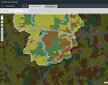
Stroud Water Research Center’s Model My Watershed App is the first national-scale tool in the WikiWatershed toolkit. It makes advanced watershed modeling easy from a Web browser, enabling anyone — professional engineers and high school students alike — to predict human impacts on stormwater runoff and water quality for any area of interest in the country.
The interface has special appeal to a young generation of digital natives who seek quick access to visual data and enjoy video and computer games. It uses stunning animation and graphics to visualize and analyze national land cover and soils maps.
Model My Watershed’s mapping capabilities produce an evolving geographical picture of watershed characteristics and data as students create and model scenarios on the land surrounding their schools. Users can model how a variety of land-use changes, such as conservation practices or a newly developed site, could alter local water quality and the flow of water through their watersheds.
Additionally, the app’s integration with The Concord Consortium’s Innovative Technology in Science Inquiry portal enables teachers to customize the curriculum, including the browser-based classroom activities.
Research led by Millersville University and an external evaluator will measure the effectiveness of teacher-training workshops and student gains in content knowledge, science skills, and interests in STEM careers, that is, careers in science, technology, engineering, and math.
“This is a fun and interactive way for students to learn about their watersheds and develop problem-solving skills. But what’s really special is that it’s both place-based and problem-based,” says Kerlin.
“Students can analyze watersheds to understand environmental issues and choose from a set of solutions, model them using the app, and then see what happens. It’s pretty exciting. We hope more students will consider STEM careers that require systems and spatial thinking because of this project.”